Braunton Burrows in North Devon has been designated as Internationally important by UNESCO.
It is the first site in the UK to be made a UNESCO Biosphere Reserve.
( UNESCO ---- United Nations Educational, Scientific and Cultural Organisation )
UNESCO's Man and the Biosphere Programme (MAB)
Braunton Burrows Biosphere Reserve
what are Biosphere Reserves?
Other Biosphere Reserves in the UK
NORTH DEVON BIOSPHERE OFFICIAL WEBSITE
North Devon Biosphere. North Devon Focus Area Project
Youtube video
Constructed Wetlands
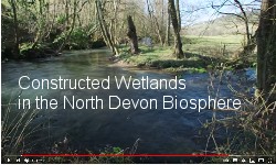
Developing partnerships and managing projects for a sustainable future in north Devon, The North Devon Biosphere team work to maintain our world class environment and the high quality of life we get from it. We are here to help and advise and facilitiate partnerships and projects.
North Devon's Biosphere Reserve is jointly funded by Devon County Council, North Devon Council, Torridge District Council
The North Devon Biosphere Reserve has a core area centred on Braunton Burrows, stretching out into what are called buffer zones and the transitional areas, to include Braunton Marshes and Great Field, Northam Burrows, Kipling Tors, Croyde Dunes and the Taw and Torridge Estuary.
There is a strong local tradition of respect for the land and sea and a warm welcome to like minded visitors wanting to look, learn and appreciate.
How have the boundaries been drawn?
The geographical area of the North Devon's Biosphere Reserve has not been plucked out of thin air. It is where it is because biospheres are living (working) ecosystems. The North Devon biosphere is based on water flowing from its source via the rivers out to sea.
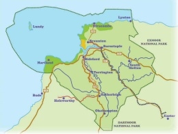
Rain which falls on farmland, roads or driveways eventually finds its way into streams and rivers. The area of land that catches rainfall for a river is known as the catchment. The biosphere catchment includes the wide swathe of countryside, which connects all the streams to the
Taw and
Torridge rivers. In short, you live in the North Devon biosphere if you live in the water catchment area of the Taw and Torridge (or smaller rivers running into the sea from
Lynton and Lynmouth to
Hartland.)
The catchment area begins high up on Dartmoor and Exmoor at the source of the Taw and Torridge rivers and follows the water, down through the villages and towns of North Devon and on out to sea, to
Lundy Island and beyond. This is why many small towns:
Chulmleigh,
Witheridge,
South Molton,
Winkleigh,
Hatherleigh,
Torrington,
Bratton Fleming and their surrounding villages are in the biosphere and just as important to its existence and well-being as the world-famous Braunton Burrows (at its heart) and of course the coastal area of outstanding natural beauty (AONB). The water then flows out to sea affecting sea life around
Lundy Island and beyond and so our biosphere includes Lundy Island and a substantial area out to sea.
The biosphere designation has also been given to North Devon because it has a strong cultural and local identity. It is through water that everyone living and working in the biosphere is connected with everyone else.
Braunton Burrows
Braunton Burrows are the core of the country's first Man and the Biosphere Reserve.
It is a world-class designation that makes the status of the area equal to that of other world-wide Biosphere Reserves such as the Danube Delta, the Hawaiian Islands and the Great Gobi.
Braunton Burrows is the largest sand dune system in the United Kingdom. It hosts an extraordinarily diverse plant community, with over 400 recorded species of vascular plants. This in turn means that there are also a great variety of associated invertebrate species.
Nearly 500 species of wildflower have been recorded here, helping to make Braunton the most biodiverse parish in England. So much can be found, from common species such as yellow iris to rare species such as sea stock, sand toadflax and water germander - the latter being so rare that it is only found at one other site in England. The carpets of flowers encourage butterflies and 33 species of these beautiful creatures have been found here.
The Offwell Woodland and Wildlife Trust website has comprehensive information on Braunton Burrows
Offwell Woodland and Wildlife Trust Biospheres
Braunton Burrows Plant Species List
Braunton Burrows Moth Species Lists
Braunton Image Gallery
Braunton Countryside Centre
Braunton Countryside Centre Illustrated Talks
Braunton Countryside Centre is the main visitor centre that houses displays and information on North Devon's internationally acclaimed Biosphere Reserve that includes the vast sand dunes of Braunton Burrows, the historic Braunton Great Field, the coastal grazing land of Braunton Marsh and the Taw/Torridge estuary.
The Centre helps visitors to appreciate and enjoy these special places with attractive displays that include a marine tank with many live rock pool creatures, a freshwater tank with live sticklebacks, photographic displays of the spectacular flora and fauna and video showings.
The Centre is run entirely by local volunteers and is funded solely by voluntary donations.
North Devon Areas of Outstanding Natural Beauty (AONB)
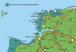
The AONB is one of Britain's Finest Landscapes and contains a surprising diversity of scenery, landscapes and habitats and encompasses the
Hartland Heritage Coast,
North Devon Heritage Coast and the internationally famous UNESCO Biosphere Reserve centred on
Braunton Burrows.
The North Devon AONB is one of a family of
Protected Landscapes in the South West, which has been designated and is the responsibility of the
Countryside Agency. These include
Dartmoor National Park and
Exmoor National Park and 12 Areas of Outstanding Natural Beauty, which together cover 37% of land in the South West Region.
North Devon AONB was designated in 1959 and covers approximately 171 km sq of coastal landscape, from
Marsland Mouth on the Cornish border, to
Combe Martin and the boundary with Exmoor National Park .
Explore The Coast
Explore the Coast; a map-based site from the North Devon Coast Areas of Outstanding Natural Beauty. Locals, day trippers or holiday makers - there's so much to explore here on our magnificent coast! This website will help you and your family explore the fascinating and beautiful coastline.
South West Coast Path
The South West Coast Path starts at Minehead in Somerset and runs along the part of the Somerset Bristol Channel coast, across North Devon, right round Cornwall, then along the South Devon and Dorset coasts to Poole Harbour. This is a distance of 630 miles which is over twice the distance of the Pennine Way and makes it by far the longest National Trail in Britain.
The Official Guide to the South West Coast Path
Discover Culture
Discover Wildlife
Discover Heritage
Discover Geology
Day By Day Guide
Route Changes
Distance Calculator
South West Coast Path Shop
Hartland Peninsular
Explore the South West Coast Path
Matthew.Alltons South West Coast Path Walks
Minehead to Barnstaple
Barnstaple to Hartland Quay
Hartland Quay to Newquay
Tarka Trail
The
Tarka Trail is a pedestrian and cycle way that runs in a 180 mile figure-of-eight through landscapes little changed from those described by
Henry Williamson in his classic 1927 novel Tarka the Otter. It passes through towns such as
Lynmouth,
Barnstaple,
Bideford,
Torrington,
Okehampton and
Ilfracombe and parts of it coincide with the
South West Coast Path, the
Two Moors Way and the
Dartmoor Way.
Tarka Trail - Braunton to Meeth
Over 30 miles of the Tarka Trail is available to cyclists between
Braunton and
Meeth, using the
old railways of North Devon. Passing through the largely unspoilt countryside as it was described by Henry Williamson in his classic novel 'Tarka the Otter' first published in 1927.
The Braunton-Meeth section of the Tarka Trail is accessible from the
North Devon Link Road (A39T), also the B3233 and A386 between Bideford and
Hatherleigh. There is also a rail link from
Exeter to Barnstaple (
the Tarka Line)
Tarka Trail
Along the Tarka Trail are 21 "discovery posts" with information on the history and wildlife of the Trail and the places it passes through. Each post has a number on the top that relates to an audio clip where you can find out more. These clips have been recorded by people involved in the management and heritage of the trail including Northern Devon Coast and Countryside Service, The Environment Agency, North Devon Museums, The RSPB, Natural England and Butterfly Conservation. Download these clips to your MP3 player or phone and find out about some of the things that make the Tarka Trail a unique experience.
Tarka Trail audio downloads
The following links are to the
Devon County Council
Tarka Trail website
Braunton to Barnstaple
Barnstaple to Bideford
Bideford to Torrington
Torrington to Meeth
Some advisory codes of conduct for users:
Responsible Use Of The Tarka Trail
General Users  Guidance for Horse Riders
  Frequently Asked Questions
Tarka Trail Map
Wildlife on the Tarka Trail
The Tarka Line

Passenger services on the line are operated by
First Great Western using
Class 142,
Class 143,
Class 150 or
Class 153 diesel multiple units. During the summer months a Sunday-only service operates (on behalf of Devon County Council) between Exeter Central and Okehampton. The Tarka Line is one of the railway lines supported by the
Devon and Cornwall Rail Partnership, an organisation formed in 1991 to promote railway services in the area. The line is promoted by many means such as regular timetable and scenic line guides, as well as leaflets highlighting leisure opportunities such as walking or visiting country pubs.
Great Scenic Railways - Tarka Line
The Tarka Line Rail Ale Trail was launched in 2002, the first of several such schemes which encourages rail travellers to visit pubs near the line.
Experience the beauty of the Devonshire countryside.
Travelling by train takes you on a journey running 39 miles between the Cathedral City of Exeter and the historic market towns of Crediton and Barnstaple. The Tarka line is one of the country's most scenic rural branch lines and follows the course of the Yeo and Taw valleys, offering picturesque views of the Tarka countryside.
The North Devon Rail Users Group
Timetable Exeter - Barnstaple (The Tarka Line)
The Tarka Line
Stations
Exeter Central
Exeter St Davids
Newton St. Cyres
Crediton
Yeoford
Copplestone
Morchard Road
Lapford
Eggesford
King's Nympton
Portsmouth_Arms
Umberleigh
Chapelton
Barnstaple
Explore Braunton
Explore Braunton
Farming
Saunton
Shipping
Braunton Burrows
Village Life
Gallery
Walks
After two years of development, the Explore Braunton Project provides a fantastic opportunity to learn and explore more about this area.
Braunton is recognised as an Area of Outstanding Natural Beauty, a defined Heritage Coast and is also in the heart of the UK's first Biosphere Reserve, recognition of its' international assets in terms of landscape and biodiversity.
Audio visual GPS tours are available to the public throughout the summer holidays from the
Countryside Centre in Braunton for a unique tour experience.
Alternatively, download your own virtual tour and learn more about the area and its' history on
www.explorebraunton.org/video-audio-tours.aspx any time throughout the year.
There are fantastic selections of walks to choose from, some of which include:
D-Day and the Dunes, an opportunity to relive the experiences of our D-Day heroes in training for the Normandy landings in the breathtaking dunes of Braunton Burrows.
Shifting Sands, explores the unique environment recognised by UNESCO as their first Biosphere Reserve in the UK. Walk on the wild side in the magnificent landscapes at Saunton Sands in this Area of Outstanding Natural Beauty.
Braunton on the Move, steps back in time into the lives of our ancestors and see their impact on this beautiful area from the Middle Ages to the coming of the railway, once carrying 10,000 passengers a day through Braunton.
Braunton Marshes
In 2007 The Taw Torridge Estuary Forum compiled a
Management Study for Braunton Marsh.
A comprehensive study of the historical, social, environmental and economic development of Braunton Marsh from pre-reclamation to the present day
The Need For The Project:
It is believed that the future of Braunton Marsh is now under scrutiny, due to fears of increased pressure in the Braunton area, caused by traffic resulting from the opening in 2007 of the Barnstaple Western Bypass and the new Downstream Bridge.
Also, as many of the Marsh owners, who make up the Marsh Commissioners and members of the Internal Drainage Board, are well beyond retirement age, it is now urgent to record their factual knowledge and their reminiscences.
The Taw Torridge Estuary Forum commissioned this
Management Study for Braunton Marsh
The study is in pdf format.

If you do not have Adobe Acrobat reader download a free copy
 The following is from the 'Foreward' section of the study. The study itself is very extensive.
The collection of separate pastures, collectively known as the Braunton Marshes, represents a unique microcosm of traditional rural life in North Devon. The enclosure of the Marsh in 1811 for cattle grazing, and its continued management by the Braunton Marsh Inspectors and by the Braunton Marsh Internal Drainage
Board, have created an invaluable example of traditional farming practices and methods of land drainage. Braunton Marsh is one of the few remaining marshes to be managed by an independent Internal Drainage Board. The Taw Torridge Estuary Forum has commissioned this Management Study to document and to raise awareness of the agricultural, historical, social, economic and environmental development of Braunton Marsh, which have contributed to making this area so distinctive and so important. The Study also ensures that the enormous contribution of all of the members of the marsh community in the management of the Marsh is recognised and celebrated. Without their support, this Study would have been impossible.
In our modern world, traditional practices are often not valued until they have been lost. This Study attempts to record a thriving part of North Devon's heritage and lifestyle, which deserves our full support and protection.
... Read the Full Report ...
The Toll Road
This Toll Road follows the line of the original embankment that has held back the sea from the Braunton Marshes since 1815. It leads to a car park at Crow Point. Views across the Braunton Marshes from this road are simply stunning, and the road ends in a car park at Crow Point. For those on foot or bike you can also access the American Road at Crow Point - enabling a great, fairly level, circular route around the area.
The Braunton Marsh Inspectors are an institution dating back to the original reclamation of the Braunton Marshes. The inspectors are responsible for many aspects of the management of the marshes and hold communal properties in trust on behalf of the land owners and occupiers. Duties include maintaining the communally used roads and embankments - hence the presence of a toll to cover the costs to maintain the road, car park and other services that ensure continued access and keep the Braunton Marsh so special.
See more about Braunton Marshes at
explorebraunton.org/farming with information on the history and engineering of the marshes.
There are fascinating video discussions with Rowland Dibble about the reclamation of Braunton Marshes and maintaining the water levels.
Braunton Great Field
Open Field System
The open field system was the prevalent agricultural system in much of Europe from the Middle Ages to as recently as the 20th century in places. Under this system, each manor or village had several very large unfenced fields, farmed in strips by individual families. From the 12th century onwards it was gradually replaced by private fields through various reforms in agricultural technology and local government.
One place in England where the open field system continues to be used is the village of Laxton in Nottinghamshire.
The only other surviving medieval open strip field system in England is located in Braunton, North Devon. It is still farmed with due regard to its ancient origins and is conserved by those who recognise its importance although the number of owners has fallen dramatically throughout the years and this has resulted in the amalgamation of some of the strips.
Braunton's Great Field is one of its finest assets and, although it has always been prized as an almost miraculously fertile area that 'teemed with incessant crops', it is now treasured as one of only two surviving medieval open strip field systems in England.
Such fields were the norm for our ancestors but virtually all were sacrificed in the name of development. The surviving Great Field is special indeed and it is said that to walk on land that has seen such little change for so many years is to walk into the medieval past.
Braunton Great Field is a hedgeless tract of arable land. some 360 acres in extent, lying between the village and the reclaimed marshlands of the River Taw.
The Great Field is divided into some 200 strips varying in size from 3/4 acre to 6 acres, but in 1889 there were double that number.
The lands are separated from each other by baulks, locally termed " landsherds" and "launchers." In 1840 there were 490 strips under cultivation.
The Great Field has been in existence for many generations and is one of three existing fields, originally cultivated under the Open Field system in this country.
That it existed in 1324 is shown in the entry in the Calendar of Close Rolls 1323-7 where many of the existing lands in the Great Field are mentioned.
Read more at
Devon County Council Braunton Great Field
explorebraunton Farming
A Story of Braunton
Braunton Canal
The
Braunton Canal is a cut made to straighten the course of the upper section of the River Caen, known as Braunton Pill, and to provide a new quay for the village of Braunton in North Devon, England. It crosses an area known as Braunton Marsh, which was the subject of Enclosure Acts in the early 19th Century, and was the only one of several schemes which was actually constructed.
Today the site of Velator Quay is used as a mooring for small boats. The original course of the River Caen remains as isolated ponds on the inland side of the embankments, and are an important habitat for birds. Visitors to modern-day Braunton might be surprised to learn that much of the village's economic success has been built upon its maritime history and indeed, that Braunton was once a significant ship-owning centre with strong links to the sea, not least a port of its own. At the height of Velator's success, it was a thriving, bustling, noisy port and a vastly different place to that which we see today.
Before the advent of motorised road transport, the most efficient way of
transporting produce from the village (and, notably, the Great Field) to market towns around the country was by sea. Another Braunton product was manganese ore, which came from a local mine. The same vessels that exported the cargoes returned laden with coal and limestone from South Wales and bricks from Bridgwater
WWII - D-Day Training
During the Second World War, much of the North Devon coast was used for military training in preparation for the
D-Day landings as its similarity to the coast of Normandy made it an ideal location. The entire coastal area from Braunton Burrows to Morte Point was assigned to the U.S. Army as
Assault Training Centre (A.T.C.) Croyde. (see link below)
The A.T.C. moved its headquarters from Grosvenor Square to Woolacombe and many thousands of troops with invasion barges and tanks moved into the area. At the north end of Woolacombe Beach was the demolition training area, with the billeting area of tents stretching up towards Mortehoe Junction. Morte Point was used as a target by anti-tank guns and seaborne artillery, and as a demonstration area of air-to-ground support firepower.
Croyde Bay was used for loading and unloading troops with amphibious vehicles, while assaults were practised at Baggy Point and full-scale assaults on Woolacombe Beach. Baggy Point was Area F. There were occasional casualties, but the vigorous training which the troops underwent prepared them to spearhead the landings on the Normandy beaches and so to achieve the historic victory of 6 June 1944.
The exercises which took place on the plateau fields of Baggy Point were intended to simulate assaults on enemy beaches. Dummy pillboxes were built to represent enemy gun emplacements and some show evidence of having been subjected to heavy fire and repair. There was also an observation house at the western end of the promontory and temporary roads which are still visible as earthworks.
The 146th Engineer Combat Battalion of the U.S. Army (see link below), which trained on Baggy, was among the first troops to land on Omaha Beach. The name of A. A. Augustine is scratched and set in the concrete of one of the pillboxes. The same name is listed among those killed on D-Day. The structures which survive on Baggy are not only unique as some of the most complete examples of D-Day training installations but they are also evocative monuments to those who trained here.
Instow: The U.S. Navy took over the entire foreshore to beach and dry out their landing craft after use in the Assault Training Center's amphibious exercises at Woolacombe and Saunton.
Replica landing craft were constructed with concrete at Brauton Burrows. Some are shown below photographed in 2009
explorebraunton.org World War Two
ASSAULT TRAINING CENTER NORTH DEVON
FRIENDS OF THE ASSAULT TRAINING CENTER
THE ASSAULT TRAINING CENTER
NEWS, EVENTS, PHOTOS
SAUNTON D-DAY 2019
A sixteen square mile corner of south west England, including ten miles of Atlantic coastline, beaches, cliffs, headlands and sand dunes. Forgotten for over fifty years, research has built up a definitive and detailed history of this establishment vital to the success of D-Day. The only training site where American troops destined for Normandy on D-Day learned and practised new tactics of amphibious assault.
Richard T. Bass has been researching the U.S. Assault Training Centre in North Devon for several years and first published "Spirits of the sand" in 1992 to coincide with the dedication of the ATC memorial at Woolacombe. Since then research and excavations of the training aids and buildings has progressed, the findings are published in the "Field edition". This is a very comprehensive study of all areas and liberally illustrated with contemporary and archive photographs, maps and diagrams. Richard is also a battlefield guide specialising in the American beaches in Normandy.
Eugene D. Shales
Sergeant, 3rd Platoon, Company B, 299th Combat Engineer Battalion. D-Day Preparations
Americans training for D-Day
 D-Day training at Braunton
 Northam Burrows Country Park
Northam Burrows Country Park
Northam Burrows Country Park
Northam Burrows Country Park lies at the western edge of the Taw Torridge Estuary (GR. 442/308) Lying within an Area of Outstanding Natural Beauty the Burrows forms an integral part of the newly designated United Nations Biosphere Reserve.
The Northam Burrows is a Site of Special Scientific Interest. It is about 253 hectares of grassy coastal plain with salt marsh, sand dunes and generally unimproved grasslands.
The Burrows provides one of the access points for the two miles of Westward Ho! Beach, thus combining the best of opportunities for land and marine leisure activities. The main ramped access point to the beach is available from the town of Westward Ho!
The Park is open to pedestrians at all times but there are restrictions on vehicles. The Burrows Centre is open from the end of May to early September and the toilet facilities from Easter to the end of October.
North Devon Focus Northam Burrows
North Devon Heritage Coast
North Devon Heritage Coast
The North Devon Heritage Coast stretches from the border of Exmoor National Park to the north shore of the River Taw near Braunton.
Hartland Heritage Coast
Hartland Heritage Coast
This is a 60 mile long coast of startling, rugged cliffs pounded by the Atlantic waves.
Lundy Island
Lundy Island
Lundy lies off the coast of North Devon, where the Atlantic ocean meets the Bristol Channel with nothing between it and America, a granite outcrop, three and a half miles long and half a mile wide. In the hubbub of the modern world it is a place apart, peaceful and unspoilt.
Lundy Island From Wikipedia, the free encyclopedia
During the summer months (April to October) visitors are carried on the Landmark Trust's own vessel,
MS Oldenburg, which sails from both Bideford and Ilfracombe.
During the winter months, (November to March) the Oldenburg comes out of service, and the island is served by a
scheduled helicopter service from Hartland Point. The helicopter operates on Mondays and Fridays, with flights between 12 noon and 2 pm. The heliport is a field at the top of Hartland Point, not far from the Beacon
Lundy Island Accommodation
An important part of the pleasure of the island is in the buildings, now carefully and expertly restored (as are the stone walls, gates and stiles) with the sort of craftsmanship which lifts the spirits. Most of the island's buildings are constructed from the island's beautiful light-coloured granite and many have been adapted from previous uses or made from stone reclaimed from long-since redundant buildings.
Lundy offers visitors an extraordinary range of buildings in which to stay, from the 13th century castle, a late Georgian gentleman's villa and a lighthouse to the Tibbetts and fisherman's chalet.
The 23 buildings are furnished in typical Landmark style for comfort and practicality. All have heating and some have open fires or stoves as well. Each property has baths or showers, running hot and cold water, mains, drainage and gas and electricity, apart from Admiralty Lookout which is gas powered only. Sheets, pillowcases and one hand and bath towel per person per week, are included in the price of all properties except the Barn. There is a pay phone in the Tavern.
The furniture is old and good. It is carefully chosen to suit each property. The rugs and carpets are exceptional, if seldom in their first youth. All the pictures, however humble, have some special reason for being there. You may find naval charts, shipwreck paintings, historic photographs of Lundy in the past or an engraving of Victorian gentlemen being lowered down the cliffs to collect eggs.
Each building contains a library of the sort of books a visitor might like to find - reference books on seashores, grasses, ships and suchlike, like Westward Ho! Bristol Channel Pleasure Steamers, Smuggling in the West Country, The Grey Seal, or To the Lighthouse.
Wildlife
Lundy's flora and fauna is so rich and diverse that most of the Island is a Site of Special Interest and the seas surrounding it are England's only statutory Marine Nature Reserve, so whether you are looking for birds or basking sharks; Soay sheep or seals; or even Lundy cabbages or corals then Lundy is the place to come.
Lundy is a lump of granite about 3 1/2 miles long by 1/2mile wide that rises 400 foot out of the sea where the Bristol Channel meets the Atlantic. The Island lies lengthways almost due north to south, which means that the West Side bears the full brunt of the prevailing south-westerly winds and the, sometimes, crashing Atlantic, whilst the East Side is much more sheltered. These different levels of exposure have an effect on the plants that grow on either side of the Island, and so a knock on effect on the rest of the wildlife.
Owned by the
National Trust, Lundy is financed, administered and maintained by the
Landmark Trust, a charity which restores historic buildings.
Pete Robsons Lundy Island Site
Taw Torridge Estuary
Taw Torridge Estuary Forum
The Forum now comprises 40 national, regional, county-wide and local member organisations, made up of the parish and town councils bordering the Estuary, the recreational and sporting clubs and organisations which use the estuary, the nature conservation, environmental and historical organisations concerned with the Estuary, commercial and recreational fishermen, the Ministry of Defence, the RNLI, the MCA, etc., all of which have an interest in and influence upon the Estuary.
River Taw
River Torridge
 North Devon UK

 Stand In The Park
 Bideford. Victoria Park
 Teignmouth. The Den


 5 bedroom house for sale. Bishops Tawton, Barnstaple, Devon.
 How to watch
  RT News on TV. Switch on TV. Select "Menu" then Select "Web Browser". When the web browser opens then in the input box enter " https://rumble.com/c/RTNews " then press "Enter". Add to "Favourites".
 The Embassy of the Russian Federation to the United Kingdom of Great Britain and Northern Ireland


 Sovereign Natural Empowerment
This series of videos will help you to see there is remedy in knowledge, knowledge of the truth, knowledge of true law.
 Mass Non Compliance MUST SEE !!. This is a sustained campaign, not a one-day stunt.
 Exposing the Digital ID Tyranny & The End of Privacy in the UK. Gareth Icke
 Whitney Webb. The entire UN 2030 Agenda rests on one cornerstone: your voluntary adoption of Digital ID.


 THE SEQUEL TO THE FALL OF THE CABAL. Part 17: Depopulation - Extinction Tool Number 10, Vaccination. MUST SEE !


 Claire Edwards, BA Hons, MA, worked for the United Nations as Editor and Trainer in Intercultural Writing from 1999 to 2017.
 On August 3, 1977, Cathy O'Brien testified to the 95th U.S. Congress to accuse Hillary Clinton of rape, and that she was a sex slave for Hillary and Bill Clinton 'who are bisexuals' affiliated in an elite sex trafficking ring that abuse and purchase and sacrifice children.
 TELEGRAM is a cloud-based mobile and desktop messaging app.
You've seen western TV and MSM. NOW see the TRUTH.

 ✓ Laura Aboli Channel on Telegram. Very Highly Recommended
ONLY active on Telegram and Instagram.


 Vladimir Putin Annual Press Conference. 14 December 2023


 Dr Mike Yeadon: Address to members of parliamentary special meeting 4 December 2023
Be sure to See This !!


 Andrew Bridgen MP website

 The Sovereignty & Referendums Bill.


 The frightening power of television

 Dolores Cahill. https://ProfDoloresCahill.com


 Countdown To Control The countdown to complete control is underway.




 PCP Wales have been fighting RSE in schools for some years. We must protect our children
 Video Release







 THE GREAT RISING.
MISSION STATEMENT.
 The Documentary 7/7 Ripple Effect Regarding the 7 July 2005 terrorist attacks in London .....


 Geoengineering Watch
 Join The Sovereign Fraternity
 Democracy Defined Campaign
Illegal arbitrary dispossession of homes, fabricated financial crises, unwarranted taxation, unemployment, and intolerable government molestation in the lives of innocent men and women, are all addressed herein. The catastrophic criminal inhumanity wrought upon whole populations by that miniscule number of men and women responsible for, and responsible for permitting (abetting) the Crime of Usury (money-lending-at-interest); fraudulent Fractional Reserve Lending; the issuance of national (and international) currency and credit at interest by non-national, de facto privately-owned "Central" Banks; the ubiquitous global crimes and lethality of International Monetary organisations and World Bank are confronted.
 Heritage Party Freedom - Family - Nation Join the
Heritage Party as a member £25 One-year membership
 PlandemicSeriesOfficial on plandemicseries.com


 The AONB is one of Britain's Finest Landscapes and contains a surprising diversity of scenery, landscapes and habitats and encompasses the Hartland Heritage Coast, North Devon Heritage Coast and the internationally famous UNESCO Biosphere Reserve centred on Braunton Burrows.


 Passenger services on the line are operated by First Great Western using Class 142, Class 143, Class 150 or Class 153 diesel multiple units. During the summer months a Sunday-only service operates (on behalf of Devon County Council) between Exeter Central and Okehampton. The Tarka Line is one of the railway lines supported by the Devon and Cornwall Rail Partnership, an organisation formed in 1991 to promote railway services in the area. The line is promoted by many means such as regular timetable and scenic line guides, as well as leaflets highlighting leisure opportunities such as walking or visiting country pubs.
 If you do not have Adobe Acrobat reader download a free copy

